
The Conservation Planning Team from Yayasan Konservasi Alam Nusantara (YKAN) won third place in the largest geospatial conference at the ESRI User Conference 2023. "We won third place in the People's Choice Award category," said Ghufran Zulqisthi, YKAN's GIS Coordinator, who attended the meeting.
On 7-14 July 2023, the YKAN team attended the ESRI Conference in San Diego, United States of America, to explain the use of the Geographic Information System (GIS) or Geospatial Information System (GIS) in facilitating conservation and collaborative monitoring in Indonesia.
ESRI is an American-based GIS/GIS software company whose main product is ArcGIS. ESRI holds a global conference annually to update the latest technology and share experiences with its users. YKAN, as the leading partner of The Nature Conservancy (TNC) in Indonesia, is one of ArcGIS's users.
Read: Community-Based Patrol in North Misool is Strengthened to Prevent Destructive Fishing
YKAN attended this year's conference with two agendas. First, a presentation with the theme "Defining Area for Collaborative Landscape Management in Kalimantan, Indonesia," on Wednesday, July 12, 2023. YKAN also participated in a map gallery event titled "Map of the Living Space of the Punan Batu-Benau Sajau Community."

The ESRI User Conference is the largest conference for GIS users globally. At this conference, participants can learn from global GIS experts and leaders through workshops, demonstrations, user presentations, and special interest groups.
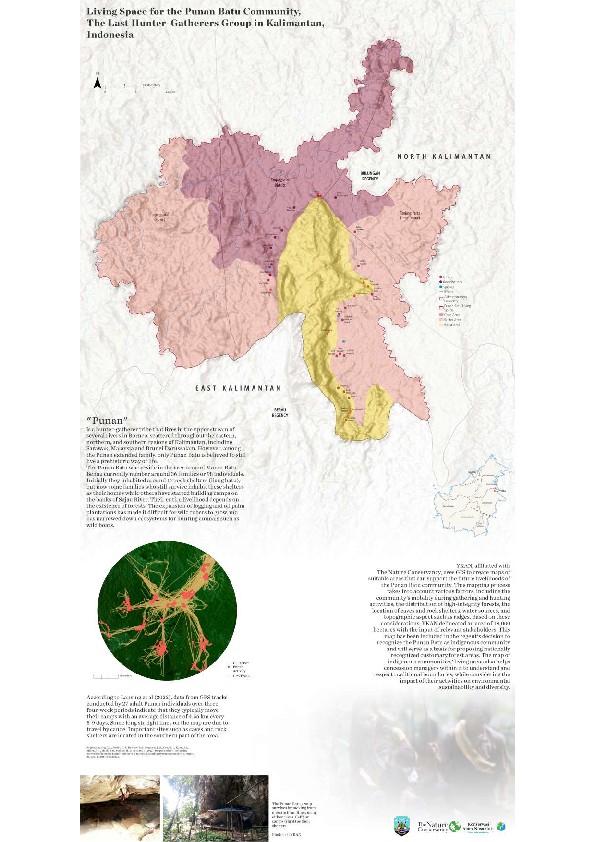
This year's conference was held at the San Diego Convention Center and was attended by around 15 thousand participants. "Before leaving, we were asked to send maps and abstracts," said Ghufran. The YKAN team sent a Punan Batu theme entitled "Living Space for the Punan Batu Community, The Last Hunter-Gatherers Group in Kalimantan, Indonesia."
The Punan Batu map was made considering that issues related to indigenous peoples still need to be discussed in global forums. "We want to present a presentation on how to utilize geospatial information systems to protect the living space of indigenous peoples," said Ghufran. The map made by YKAN describes the range, topography, and distribution of caves of the Punan Batu-Benau Sajau community.
Recognition of MHA status
The Punan Batu Benau-Sajau community has just received recognition as a Customary Law Community (MHA) by the Bulungan Regency Government, North Kalimantan. Through the Regent's Decree No 18845/319 of 2023, signed on April 3, 2023, the community, the last active hunters and gatherers on the island of Kalimantan, received their legality as indigenous peoples.
This step is an effort to achieve legal and manageable forest designation in their area. YKAN promotes the process of recognizing indigenous peoples and identifying customary forest areas. "The map we made was YKAN's proposal regarding the area of the Punan Batu customary forest of 18,000 hectares," said Ghufran.

Apart from being presented online, this living space map was also presented as a poster at the TNC booth. Ghufran explained that winning points were determined by voting during the exhibition in the People's Choice category.
"So there is an element of interest from other participants and the jury's consideration. We are grateful to be able to bring up the issue of indigenous peoples, which has attracted global attention," concluded Ghufran.
The map of the living space of Punan Batu can be accessed at the following link below:
Download
Read This Next

East Kalimantan Plantation Data Update
Yayasan Konservasi Alam Nusantara (YKAN) developed a web-GIS-based spatial database management application for the East Kalimantan Plantation Office that can be accessed online.

Dive into the Other Side of Sasi at Kapatcol
Sasi is more than just a conservation practice. Here, sasi is a place to instill various values and rely on hope.

Lessons Learned from the Wehea-Kelay Collaborative Management, East Kalimantan
YKAN has been protecting and assisting the Wehea-Kelay Landscape for more than 20 years.